AquaVIT
|
Article scientifique V. Bertrin, S. Boutry, D. Alard, J. Haury, G. Jan, S. Moreira, C. Ribaudo Prediction of macrophytes distribution: the role of natural vs anthropogenic physical disturbances Applied Vegetation Science, 2018, 21, 395-410. Questions: Do natural and anthropogenic physical disturbances equally affect the distribution of aquatic plant communities? Can hydrodynamic and geomorphological features be used to predict the establishment of macrophyte communities at the shoreline scale? Locations: Two large, shallow lakes, southwest France. Methods: Based on field observations (vegetation occurrence and anthropogenic modifications of the shore) and data generated by a geographic information system (wave exposure, wave-induced sediment re-suspension, slope and land cover), we defined sites and community groups using cluster and indicator species analyses. The groups were then analysed by means of a statistical classifier (Random Forest). These different steps in data treatment enabled us to characterize the importance of each physical factor in determining macrophyte occurrence and distribution. As a result, a predictive map to forecast aquatic plant distribution at the shoreline scale was obtained. Results: Anthropogenic disturbances were less important parameters than natural physical variables in structuring the distribution of lakeshore macrophytes. Within natural factors, wave-induced sediment re-suspension and slope had the most impact; nevertheless, the presence of swimming areas seemed to have a strong impact on aquatic habitats, being correlated with the total absence of aquatic vegetation. The predictive map obtained through the model spatially defined the position and occurrence of suitable sites for the settlement of both invasive and rare and endangered species. Conclusions: In this study, natural disturbances play a major role in structuring aquatic plant distribution over physical anthropogenic factors. The model contributes to improving knowledge on plant communities with respect to local hydrodynamic and morphological features of lakeshores. Furthermore, the model provides a predictive map as a useful tool for the management of aquatic vegetation in temperate shallow lakes. Keywords: aquatic weeds, distribution model, hydromorphological alteration, isoetids, lakeshore zone, softwater lakes, variable importance, vegetation management, wave action A retrouver ici : https://onlinelibrary.wiley.com/doi/abs/10.1111/avsc.12378 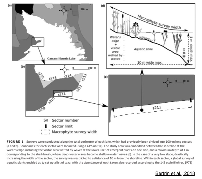 |